China’s Deep-Sea Atlas Signals New Front in Global Resource and Military Competition
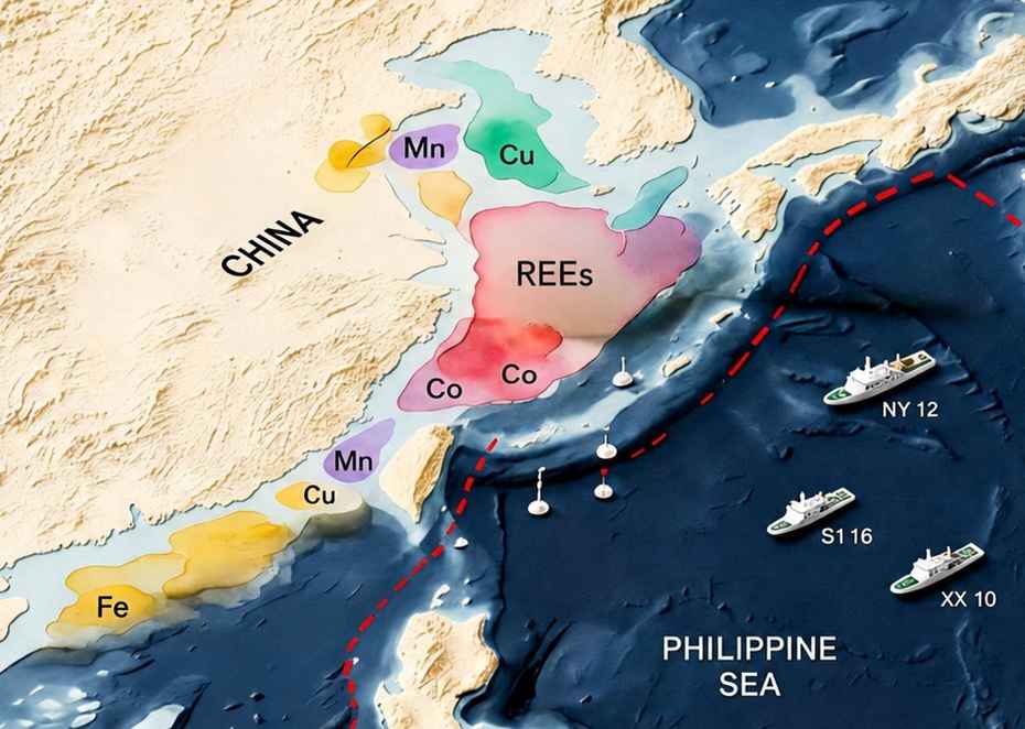
The release of a comprehensive deep-sea mineral atlas by the People’s Republic of China (PRC) in April 2026 is drawing attention from policymakers and analysts worldwide, not only for its scientific significance but also for its implications in global resource competition and military strategy. Published by the China Geological Survey (CGS), the “Atlas of Subsea Chemical Elements in the Eastern Seas” represents nearly two decades of marine geological surveys across the Bohai Sea, Yellow Sea, and East China Sea. Based on more than 20,000 sampling sites and enhanced by machine learning analysis, the atlas maps the distribution of key elements such as iron, manganese, copper, and rare earth minerals across China’s coastal waters. Chinese authorities describe the project as a milestone in oceanographic research and a tool for environmental management, spatial planning, and offshore resource exploration. But outside observers see a broader strategic intent. According to experts cited by The New York Times, the atlas underscores Beijing’s ambition to expand into deep-sea mining while reinforcing its claims in disputed maritime regions. Analysts also note its potential military applications, particularly in submarine warfare and seabed surveillance. A strategic shift toward resource controlThe atlas comes at a time when competition over critical minerals — such as cobalt, nickel, lithium, and rare earth elements — is intensifying globally. These materials are essential for electric vehicles, renewable energy systems, and advanced defense technologies. China already dominates the midstream segment of the rare earth supply chain, controlling an estimated 85 percent of global processing capacity. However, it remains dependent on foreign sources for raw materials, including cobalt from Africa and lithium from Australia and South America. The new seabed mapping effort suggests a shift in strategy: securing access not just to processing, but to the resource base itself. SinoInsider notes that the atlas effectively serves as a “navigation system” for future deep-sea mining operations, enabling China to identify high-value mineral deposits with greater precision while reducing exploration costs and risks. This could provide Beijing with a time advantage in developing offshore extraction capabilities, particularly in polymetallic nodules rich in battery metals. Such a move would position China more strongly in the global critical minerals race, potentially reshaping supply chains and reducing vulnerability to geopolitical disruptions. Military implications beneath the surfaceBeyond resource competition, the atlas also carries significant implications for military strategy. Detailed knowledge of seabed composition plays a crucial role in underwater acoustics, affecting how sonar waves travel through different marine environments. This information can influence both submarine stealth capabilities and anti-submarine detection systems. By mapping sediment composition and chemical properties across its eastern waters, China gains the ability to build more accurate acoustic models, an advantage that could enhance the People’s Liberation Army Navy’s operational effectiveness. SinoInsider highlights that such data supports the development of an “underwater defense architecture,” particularly along the so-called First Island Chain, a strategically vital region that includes waters near Taiwan and Japan. Mastery of seabed conditions in this area could allow China to reduce the traditional stealth advantages held by U.S. submarines, while improving its own detection capabilities. This aligns with Beijing’s broader anti-access/area denial (A2/AD) strategy aimed at limiting foreign military operations near its coastline. The dual-use nature of seabed mapping also reflects China’s emphasis on military-civil fusion. Technologies used for deep-sea exploration, such as robotics, sensors, and data transmission systems, can be adapted for military applications, blurring the line between scientific research and strategic reconnaissance. Maritime ambitions and regional tensionsChina’s deep-sea push is closely linked to its broader maritime ambitions. In a July 2025 speech, later published in the Communist Party’s journal Qiushi, Chinese leader Xi Jinping called for accelerating the development of a “strong maritime nation” and described the ocean as a key frontier for economic growth and national power. The release of the atlas appears to operationalize that vision. By systematically mapping its eastern maritime domain, including areas near Taiwan, China is strengthening its ability to project power and enforce maritime claims. Control over seabed data could also support potential blockade strategies or underwater operations in the event of a regional conflict. At the same time, Beijing is seeking influence in global ocean governance. Its involvement in the International Seabed Authority (ISA), which regulates deep-sea mining in international waters, reflects an effort to shape technical standards and regulatory frameworks. SinoInsider suggests that by producing comprehensive geochemical maps, China could establish data benchmarks that influence future rules. This would potentially give it an edge in both commercial and regulatory arenas. A new arena of global competitionDespite its ambitions, China’s deep-sea strategy faces significant challenges. International opposition to deep-sea mining is growing, with environmental concerns dominating recent discussions at the ISA. Several countries have called for a moratorium on mining activities, citing risks to fragile marine ecosystems. Technical hurdles also remain. In late 2025, China Minmetals reported damage to its deep-sea mining equipment caused by extreme ocean conditions, highlighting the engineering difficulties involved in operating at such depths. Geopolitical competition is intensifying as well. The United States has committed billions of dollars to developing its own deep-sea mining and processing capabilities, while Japan is strengthening its maritime security posture in response to increased Chinese survey activity. Incidents involving Chinese research vessels, such as disabling tracking systems in sensitive waters, have further raised suspicions among regional neighbors. These actions have contributed to what analysts describe as a growing “trust deficit,” complicating China’s efforts to expand maritime cooperation. The release of China’s deep-sea atlas marks a significant step in the country’s effort to expand its strategic reach from land and surface waters into the ocean depths. According to SinoInsider, the initiative reflects a multidimensional strategy encompassing resource control, military advantage, and influence over international norms. It represents an attempt to transform the deep sea into a “second territory” through technological and data-driven dominance. While the atlas provides a foundation for Beijing’s future expansion, translating seabed data into tangible economic and strategic gains will require overcoming technical barriers, navigating environmental opposition, and competition with rival powers. By Leo Timm ---------------- Signature: (This user did not write a signature.) Reply |